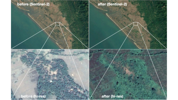
Satellite images offer a non-intrusive means to observe surface changes that hint at conflict events (e.g., burning of settlements, movements of assailant or fugitive groups). Remote sensing complements on-the-ground activities and is particularly valuable to gather information in areas that are difficult to access or pose high security risks. Humanitarian organisations like the International Committee of the Red Cross (ICRC) already use satellite data to verify and document violations of humanitarian law. However, this is done only on-demand: manual assessment is labour-intensive and requires very high-resolution images that are too costly to screen entire regions or countries on a regular basis. We argue that recent advances in AI open up a new opportunity: our idea is to develop the first automated, large-scale conflict monitoring tool. Our novel approach shall combine modern visual AI with free Copernicus imagery, notably Sentinel-1 and Sentinel-2. We believe that their ground sampling distance is sufficient to detect many relevant events with state-of-the-art machine learning: while the associated spatial and spectral signals are small compared to the sensor resolution, it has repeatedly been found that deep learning-based computer vision models are able to pick up subtle changes that elude even experienced analysts, especially when combined with a broad range of spectral bands (“imaging modalities”). At the same time Copernicus images are free and offer full coverage with high revisit rates anywhere on Earth. The new approach will enable humanitarian monitoring in near-realtime. We are already collaborating with the ICRC, the UN Department of Political and Peacekeeping Affairs and the ETH Center for Security Studies. With the proposed idea we hope to strengthen our partners’ early warning capabilities, facilitate quick assessment of humanitarian impact in the aftermath of conflicts, and support the existing documentation process.

