
Duration: 18 months
Objectives of the Product
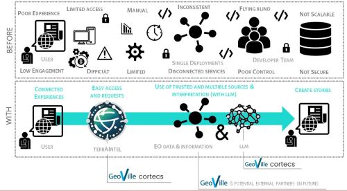
terrAIntel addresses key challenges faced by non-technical users, particularly in journalism and other public-interest workflows. These challenges include technical barriers to accessing Earth observation (EO) data products, limited interpretability without specialised expertise, delays in turning EO data into reporting-ready evidence, and a lack of transparency in data sources and methods.
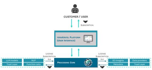
To address these obstacles, terrAIntel enables users to pose geospatial questions in natural language and receive intuitive, data-driven responses that combine map visualisation, chart-ready statistics, and plain-language explanation. The platform has progressed from a proof-of-concept into a demonstrator platform in a first controlled release baseline for early external validation.
Key features include an interactive user interface, support for map and chart outputs, configurable areas and times of interest, and provenance-rich responses that help users understand where the information comes from. In this way, terrAIntel transforms dense EO data products into accessible insights for fact-based reporting, environmental understanding, and wider decision support.
Customers and their Needs
terrAIntel primarily serves non-experts, with journalism as the lead entry segment. Current target users include digital and investigative journalists, data storytellers, and media-related users who need intuitive access to EO-backed evidence without having to work directly with complex EO tooling.
In parallel, early validation and showcase activities are underway to explore adjacent user groups in the public-interest and operational sectors. Across these groups, the core need is consistent: users want to ask questions in natural language and receive understandable answers through maps, statistics, and transparent metadata, without requiring specialised EO expertise.
terrAIntel addresses these needs by improving accessibility, interpretability, and timeliness. Ongoing pilot feedback and early user engagement help ensure that the platform continues to evolve in line with real user workflows and reporting needs.
Targeted customer/users' countries
terrAIntel targets a global user base. Outreach and validation activities currently focus on journalism networks, while also engaging adjacent public-interest and operational stakeholders through partner networks, early-access programmes, showcases, and conferences. The platform’s versatility across EO topics and user profiles positions it well for broader international market reach as adoption matures.
Product description
terrAIntel is an intuitive, user-facing platform that allows users to query EO data in natural language. By connecting a conversational interface with EO data access, map visualisation, chart-ready statistics, and plain-language explanations, the platform enables non-experts to go from a geospatial question to usable evidence quickly.
What distinguishes terrAIntel is that it does not only improve access to EO data products; it also helps users interpret them. Users can define where and when they are interested, explore results visually, request structured outputs, and review provenance information that supports trust and attribution. This makes EO data more approachable for users who need insights rather than raw technical products.
Added Value
The EO industry faces a significant challenge with an overwhelming influx of data that is difficult to manage, access, and reuse effectively. This often results in EO data products being created as one-off outputs and subsequently forgotten. terrAIntel addresses this problem by enabling a broader range of users to interact with EO data without requiring extensive prior training. By improving accessibility and usability, terrAIntel empowers non-experts to derive meaningful insights, expanding the industry’s user base and promoting long-term data sustainability.
What distinguishes terrAIntel is its combined focus on accessibility, interpretability, and transparency. While many solutions focus primarily on data access, terrAIntel helps users understand and work with EO data through natural-language interaction, map and chart outputs, and provenance-rich explanations. This reduces reliance on specialised expertise and makes EO data more useful to a wider range of non-expert users.
Current Status
The terrAIntel activity kicked off on 9 December 2024 and successfully passed the Critical Design Review (CDR) on 11 September 2025. Since then, the project has progressed from integrated prototype work to an externally presentable demonstrator platform and, more recently, to a first controlled release baseline for early external validation.
The platform now supports an end-to-end flow from natural-language query to EO retrieval, map visualisation, and chart-ready outputs, while ongoing hardening and validation continue ahead of the remaining project review steps. In parallel, terrAIntel’s public-facing outreach has expanded through a landing page, LinkedIn communication, early-user engagement activities, and planned showcase/conference participation to gather feedback from target users and adjacent stakeholders.