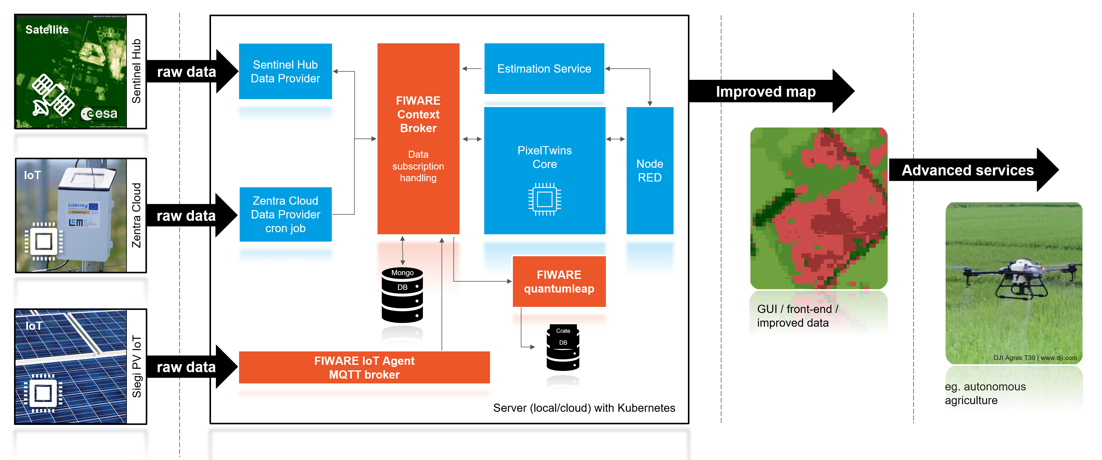
The project “Pixel Twins – integrating Earth’s surface into the internet of things” divides the earth’s surface into equally sized pixels which are then linked with EO data and satellite data. These data can be combined using use-case-depending mathematical algorithms. The satellites provide area wide EO data which are combined with the timely continuous IoT data in order to calculate area wide and timely continuous estimations. This allows that even coarse-resolution EO data can be calibrated with high-accuracy local IoT data. The overall result is a significantly increased data quality which enables new fields of applications.
The approach has been applied on two different use case in the Pixel Twins project: smart farming and photovoltaics. In the smart farming use case, NDVI data from Sentinel-2 satellite is combined with local IoT-based captured NDVI data. The result is an improved and continuously available estimation of NDVI data around the IoT sensors. The photovoltaic (PV) use case presents possible improvements of estimating the energy potential at different geographical locations using IoT data sources of real PV installations. Historical EO data is used to calculate average cloud coverage which then enhanced with one-year IoT data. The result is an improved energy potential estimation around the IoT sensors. In both use cases, a web-based GUI has been implemented to support the demonstration of the implemented solution.
CHALLENGE: Valuable earth observation data is available for every square meter of the earth. A plethora of yet unconceived services and business ideas could build upon this information. This is an intriguing parallel to the evolving internet of things (IoT): In the IoT this information is provided by addressable. The EU has invested heavily to create a framework to help software developers to transform IoT data into value for businesses and society. This framework is called FIWARE [www.fiware.org]. It connects IoT devices with services that build upon data provided by those devices. This is what we aim at for ESAs satellite data. SOLUTION: We want to make the Earth’s surface part of the IoT. Earth observation data should blend seamlessly into the evolving software architecture and data access protocols of the IoT. Therefore, we transform the entire surface of the Earth into virtual IoT devices. Each Earth surface fragment of e. g. 3 times 3 square meter will become an identifiable and addressable IoT object (“Pixel Twin”). Each Pixel Twin is a gateway to all data available from Earth observation access portals, associated with this fragment of the Earth. The Pixel Twin lives within the FIWARE IoT framework and its internationally acknowledged standards for data and service access interfaces (i.e. NGSI-LD). IMPACT: We envision a world in which you can communicate with every fragment of the Earth’s surface, by addressing its Pixel Twin. Pixel Twins provide information along the increasingly spreading communication culture of the IoT. They become a natural part of our economy. Pixel Twins can also provide or demand services themselves. E. g., if a Pixel Twin in a city turns out to be a heat island, it can ask the landlord to plant a tree. The landlord can be paid based on actual reductions in infrared radiation of that very Pixel twin in the years to come.

