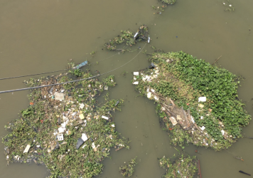
Rivers are a main source of marine plastic pollution. Current estimates of plastic emission into the ocean are uncertain due to a lack of observations. Remote sensing offers the possibility to scale up data collection in time and space. Most riverine macroplastic items are between 1 cm and 1 m in size and cannot directly be detected from space. However, recent data from the Saigon river (Vietnam) showed a relation between vegetation patches and river plastic. Water plants function as accumulation zones, entangling plastic items. Preliminary analysis has demonstrated that such patches can be detected using images from ESA Sentinel-2 satellites, and potentially be ‘unmixed’ to determine if patches are dominated by vegetation, plastic or non-plant debris. In the proposed research, we further explore opportunities of plastic monitoring by using aquatic vegetation as a proxy. First, we will optimize a vegetation detection algorithm using data from the Saigon river. A 10-month daily in situ dataset (including organic and plastic material concentrations, and plastic item mass and size distributions) is available to train the algorithm. These data will be used to establish a relation between vegetation and plastic mass. Second, vegetation will be detected and analyzed using available Sentinel-2 images for 2018. We will focus on the stretch from Ho Chi Minh City to the river mouth. The seasonal variation in vegetation patches and the estimation of plastic transport will be compared with the field data. Finally, the approach will be applied to estimate plastic transport in the Mekong river, as this is one of the world’s most plastic emitting rivers. With this project we aim to (1) demonstrate that vegetation can be used as a reliable proxy for riverine plastic pollution, and (2) provide new estimates of plastic emissions into the ocean from the Saigon and Mekong rivers and beyond. This will contribute to optimizing plastic prevention and collection strategies.

