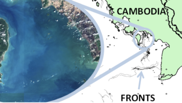
Fronts in coastal and oceanic regions are biologically rich locations, where developing satellite remote sensing detection of marine plastic debris could be valuable for monitoring far reaching impacts, as indicated by a recent user consultation. We propose a risk detection prototype for marine plastic debris accumulated at fronts . The approach is to combine advanced optical and radar processing techniques with front detection algorithms and dispersion models. Fronts are the interface between water bodies varying in temperature, salinity or colour, enhance primary production and create biodiversity hotspots. We hypothesise that fronts also aggregate floating plastics, supported by the indicator developed through the ESA OPTIMAL study by the Plymouth Marine Laboratory (PML). This study will focus on the polluted coastal zone of Cambodia. Matching the PML indicator for floating aggregations with existing front detection algorithms, frontal areas will be targeted for validation using very high resolution and hyperspectral imagery (e.g.PRISMA) and in situ sampling. We will apply different Earth observation data (Sentinel-1 SAR, Sentinel-2 MSI, Cryosat-2 , Sentinel-3 SRAL and OLCI and AVHRR) to assess the relationship between litter and fronts at a range of spatial and temporal scales and produce risk maps. To investigate the sources of aggregates on fronts, we will also perform Lagrangian model simulations, linking coastal sources to impacts offshore. Providing a validated dataset from satellite assets is very innovative and a fundamental element for the development of machine learning algorithms. Risk maps will help saving costs to regional monitoring agencies guiding clean-up operations to areas of potentially high debris accumulation and conservation threat, where no other detection methods exist. The results from this study pave the way for a global evidence based service of robust indicators for UN Sustainable Development Goals (SDG14) from remote sensing assets.