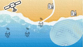
A combined satellite-based solution is proposed to map plastic marine litter pathways and accumulation areas relying onto 3 innovative developments: 1) Utilising machine learning alongside an augmented land cover classification, accumulations of plastic litter across coastal and riparian zones will be mapped. Through a combination of satellite spectral data and calculated thematic indices, the proposed random forests algorithm will be trained to monitor and help the mitigation of marine plastic pollution at its sources. 2) Inspired from designed-to-drift MAR-GE/T beacons with GPS positions relayed through the Argos satellite system, the proposed novel satellite tracker will be specifically designed to track plastic litter pathways, with better precision and realistic behavior. This miniaturized device will be designed for easy integration in different macro-plastic litter-like platforms and a low-cost and reduced environmental footprint approach will allow batch deployments enhancing the tracking efficiency. 3) Ocean surface currents and winds play a primary role in the transport and dispersal of plastic marine litters. A multi-year observations of ocean currents from space, in a synergetic use of satellite sensors (altimetry, scatterometers,...) and in-situ buoys, will be computed and used within a lagrangian drift modelling tool to simulate the plastic litters pathways, map the hotspots. The combination of these 3 components will constitute a full-range monitoring system of plastic marine litter, from littering sources determination to hotspots and pathways identification. This system would provide information to help both cleaning and littering reduction actions.

